Mapping study gives first glimpse of deep reefs beneath Bass Strait
Media release
Scientists have captured imagery of a newly discovered underwater landscape beneath the waves in Bass Strait, revealing a complex seabed of deep reefs that have been sustaining life for fish and other fauna for millennia.
Using state of the art sonar equipment, a team from Deakin University's marine mapping group has scanned the seafloor in the Apollo Marine Park, south of Cape Otway in south-west Victoria.
Researchers believe the area is an important hotspot for marine biodiversity, including habitats supporting deep water corals, sponges, fish communities and commercially important rock lobster.
Associate Professor Daniel Ierodiaconou from Deakin University said the initial voyage had provided critical baseline information that will allow marine park managers to develop a habitat inventory of the park and learn more about its unique biodiversity values.
"Not only is this information critical to our understanding of the marine park in Bass Strait, it will also help Parks Australia target future research efforts, including where to deploy underwater cameras, so that we can learn more about these rarely seen marine communities and individual species far below the water’s surface," said Professor Ierodiaconou.
The Deakin University team, in partnership with iXblue and Parks Australia, conducted multi-beam sonar surveys aboard Deakin's research vessel, MV Yolla, in January this year.
Director of National Parks and head of Parks Australia, Dr James Findlay, said the results from the mapping had helped identify new reefs which are providing critical habitat for fish and other animals.
"We're focused on delivering healthy, resilient and well-managed marine parks that enhance biodiversity and provide socio-economic benefits. Detailed mapping of the sea floor and other science is fundamental to achieving this management vision," said Dr Findlay.
The 58 marine parks around Australia managed by Parks Australia play a vital role in protecting our unique and precious offshore marine environment.
KEY FACTS
- The Apollo Marine Park extends over an area of 1184 km² and starts in depths less than 50 metres near Apollo Bay, deepening offshore to around 100 metres.
- During the eight day mapping project in January, the MV Yolla travelled more than 884 kilometres within the marine park, and mapped more than 119 square kilometres of seabed or ten per cent of the marine park.
- The latest mapping data reveals finescale seabed features and habitat characteristics including the extent of reefs, ancient shorelines and river systems that would have flowed when the sea level was lower, many thousands of years ago.
- The Apollo Marine Park also includes an ancient river valley from the last ice age, around 18,000 years ago.
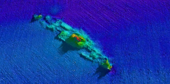
- The wreck of MS City of Rayville, the first American ship to be sunk during WWII, also lies within Apollo Marine Park. During the voyage, the research team took the opportunity to gather some detailed information about the American freighter which will feed into future preservation efforts.
- The data gathered during this voyage is part of an ongoing commitment by Parks Australia to invest in new science to support effective marine park management.
- For more information about the marine parks, visit parksaustralia.gov.au/marine