Studying our coastlines from the sea and the sky
Deakin news
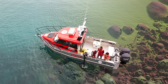
Drones, remotely operated underwater vehicles, advanced sonar, and a purpose-built research vessel are just some of the high-tech tools Deakin University’s Marine Mapping group are using in their work to map and monitor coastal areas of Victoria and beyond.
Daniel Ierodiaconou, Associate Professor of Marine Science in Deakin’s School of Life and Environmental Sciences, is the group’s leader.
‘We have maps of the land, but when we get to the coast we hit an information void,’ Associate Professor Ierodiaconou explains.
‘Our team use some of the latest advances in marine science technology to collect information of the distribution of plants and animals and the physical structure of the seabed and coastal zone.
‘This allows us to model the distribution of important assets such as areas supporting fisheries as well as monitor changes through time such as the impact of storm events on our coasts.’
It has been a busy year for the Deakin Marine Mapping group so far, marked by some key achievements and a new unit offering.
Earlier this year it was announced the group would be leading a $3 million project, together with the Department of Environment, Land, Water and Planning (DELWP) and the University of Melbourne, as part of the Victorian Coastal Monitoring Program (VCMP). This has included the recruitment of four new staff at Deakin’s Warrnambool Campus and two additional PhD students joining the Marine Mapping group.
The VCMP aims to provide communities with information on coastal condition, change, hazards, and the expected longer-term impacts associated with climate change that will support decision making and adaptation planning.
An exciting aspect of the program is the use of citizen science coastal monitoring. Volunteer groups from around Victoria are receiving training in drone technology and field surveying and using cloud-based data processing to produce high-resolution digital models of shorelines and sediment change.
‘It is amazing how far the technology has come that now allows us to equip our citizens with training and equipment to produce high quality data that they, scientists and managers can use,’ Associate Professor Ierodiaconou says.
‘This includes high resolution, three-dimensional models of shorelines to look at the impacts of coastal erosion.
‘We have also teamed up with Australian company Propeller to provide a web platform for our citizens and managers that enables them, with minimal training, to interact with the drone data to monitor change.’
Associate Professor Ierodiaconou says although it is early days, he is excited by the rate of uptake of this new data by stakeholders, including the recent assessment of erosion impacts on the Great Ocean Road in Apollo Bay.
‘The uptake has been diverse,’ he says. ‘Citizens are using the data to better inform themselves of coastal change; government agencies are using this data to improve coastal monitoring, and consultants are using this data for coastal hazard assessments.’
The Marine Mapping group manage Deakin’s commercial drone operations. The group has also developed a unit to give students the opportunity to develop drone skills. Landscape Drones is a one-week intensive at Deakin’s Warrnambool Campus with some self-paced Cloud (online) learning.
‘It’s an exciting time in terms of the technology at our disposal and Unmanned Aerial Vehicles – UAVs or drones – are filling an important knowledge gap across a range of disciplines,’ Associate Professor Ierodiaconou says.
‘This unit will give students hands-on experience in capturing and advanced analysis of that data and, importantly, an understanding of the requirements for safe drone operations under the Civil Aviation Safety Authority drone regulations.’
The Landscape Drones unit is offered for the first time in November (Trimester 3) this year. To commence study in November current students must apply via StudentConnect. Applicants for single-unit/non-award subject enrolments are encouraged to apply through the Deakin Applicant Portal. The closing date for Trimester 3 enrolment is Sunday 18 November 2018.
Another highlight for the Marine Mapping group in 2018 was the Victorian Coastal Awards. Deakin, together with Parks Victoria and The University of Melbourne, won the Partnerships in Research and Monitoring award for the Victorian Marine Park Habitat Mapping and Monitoring Program. The program’s project team was described as making ‘many scientific advances of global impact, placing Victoria at the forefront of marine habitat science’.
‘The award is a recognition of the great contributions of students and staff past and present to programs supporting the monitoring of our Marine National Park Network,’ Associate Professor Ierodiaconou says.
‘This includes using sonar science aboard our Deakin research vessel Yolla to map the marine park estate, filling major gaps in knowledge of the distribution of habitats. They are also using sonar as part of the VCMP to understand offshore sediment supply for our beaches.
‘It also includes thousands of observations taken to understand how marine communities are changing through time, including sampling of fish communities using baited camera technologies.
‘Through this alone over 25,000 individual fish have been identified and measured across 1200 locations, so we can track changes through time and identify areas of biodiversity significance.’
Visit the Deakin Marine Mapping website to find out more about the group and their projects.
Share this story